Ficheru:Via Egnatia-en.jpg
Saltar a navegación
Saltar a la gueta

Tamañu d'esta previsualización: 733 × 600 pixels. Otres resoluciones: 293 × 240 pixels | 587 × 480 pixels | 939 × 768 pixels | 1100 × 900 pixels.
Ficheru orixinal (1100 × 900 píxels, tamañu de ficheru: 420 kB, triba MIME: image/jpeg)
Resume
| Descripción |
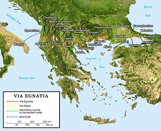
English: English map of the ancient Roman Via Egnatia crossing the South of the Balkans.
Français : Carte en anglais de l'antique Via Egnatia romaine traversant le sud des Balkans.
Deutsch: Englische Karte der Via Egnatia (griechisch Ἐγνατία Ὁδός) eine römische Straße die Adriaküste mit dem Bosporus verband |
||
| Data | |||
| Fonte |
Own work; |
||
| Autor | Eric Gaba (Sting - fr:Sting) | ||
| Permisu (Cómo reutilizar esti ficheru) |
|
||
| Otres versiones |
[]
|


Llicencia
Yo, la persona titular de los drechos d'autor d'esta obra, espublízola baxo la siguiente llicencia:
This file is licensed under the Creative Commons Attribution-Share Alike 2.5 Generic license.
- Ye llibre:
- pa compartir – pa copiar, distribuir y comunicar públicamente la obra
- pa remezclar – p'adautar la obra
- Baxo les condiciones siguientes:
- reconocimientu – Tienes de dar el créitu apropiáu, apurrir un enllaz a la llicencia ya indicar si realizasti dalgún cambéu. Puedes faelo de cualquier mou razonable ,pero non de manera que suxera l'encontu del autor pa ti o pal usu que faigas.
- compartir igual – Si entemeces, tresformes o te bases nesti material, tienes de distribuir les tos contribuciones baxo la mesma llicencia o una compatible cola orixinal.
Historial del ficheru
Calca nuna fecha/hora pa ver el ficheru como taba daquella.
| Data/Hora | Miniatura | Dimensiones | Usuariu | Comentariu | |
|---|---|---|---|---|---|
| actual | 22:55 10 xun 2006 | | 1100 × 900 (420 kB) | wikimediacommons>Sting | {{Information |Description=Map of the antic Roman Via Egnatia crossing the South of the Balkans |Source=''For the source of data and the modern name of the cities, see the'' '''[[|discussion page]]''' |Date= June 2006 |Author= Eric Gab |
Usu del ficheru
La páxina siguiente usa esti ficheru: